Thinking about buying on Shawano Lake but torn between open-lake frontage and a channel lot? You are not alone. The choice affects your day-to-day boating, how much maintenance you take on, what you can build, and long-term resale. This guide breaks down the real differences you will feel as an owner and gives you a simple, local way to compare listings with confidence. Let’s dive in.
Shawano Lake snapshot
Shawano Lake is one of Northeast Wisconsin’s most popular recreational lakes, covering about 6,178 acres with basin depths up to roughly 40 feet. The lake has a large shallow zone and seasonal aquatic plant growth that local groups track and manage. You can review waterbody facts and management activity on the Wisconsin DNR’s Shawano Lake page for helpful context before you shop (Shawano Lake watershed overview).
Local volunteers and partners help keep channels navigable and monitor plant growth. Shawano Area Waterways Management (SAWM) shares aquatic-plant surveys, treatment summaries, and navigation updates that are valuable for buyers considering both open-lake and channel homes (SAWM aquatic management).
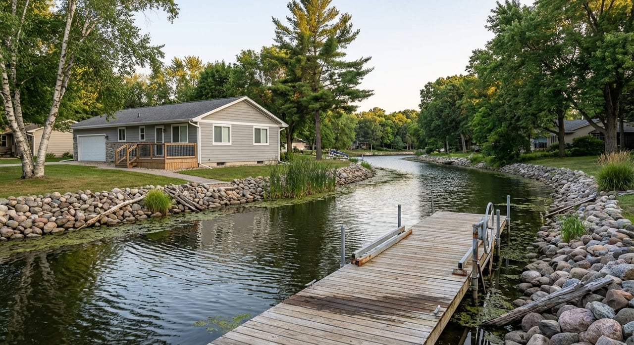
Lakefront vs. channel: what it means
How to tell the difference
- Lakefront: Your shoreline faces the main body of open water. You typically get broader views, more wind and wave exposure, and deeper water near the dock.
- Channel-front: Your shoreline sits on a narrower connector or bay that links to open water. Channels are often calmer and more sheltered, but they can be shallower with more aquatic vegetation.
SAWM’s navigation committee buoys certain areas and manages spot harvesting to keep channels passable. If you are evaluating a channel property, check current navigation notes and buoy placement (SAWM navigation and safety).
Lot shape, frontage and structures
Shoreline feet are a major factor in both use and value. Many comparisons start with price per shoreline foot, which you can measure in the Shawano County GIS viewer (County maps and land records).
Know the rules before you rely on existing docks or plan new work. Wisconsin DNR regulates piers and slip counts for non-commercial parcels, and legacy piers may follow different allowances. The state’s guidance is your baseline for what you can place on the water (DNR piers and recreation guidance). Local shoreland rules also apply. Shawano County commonly requires a 75-foot setback from the ordinary high-water mark for most structures, with specific limits and exemptions. Review the county’s shoreland information early in your process (Shawano County 75-foot setback info). If your property is within the City of Shawano, check municipal overlay standards too (City of Shawano code reference).
Boating and daily use differences
Access and navigation
On open lake, you usually enjoy deeper water right off the shore and a direct run to wide water. On a channel, you may travel a short distance at no-wake speed before reaching open lake. Channels can be narrower for turning and may get busy at peak times, though many feel quieter on typical evenings. SAWM provides updates on buoying and spot harvesting that affect day-to-day navigation in channels (SAWM navigation and safety).
Public launches and convenience
Even if you own a dock, proximity to public ramps matters for guests, winter storage logistics, and larger craft. Shawano Lake offers multiple public access points, including the county site at Cattau Beach. You can review location details and parking considerations here (Cattau Beach access info).
Pre-offer boating checks
- Confirm water depth at the dock area in a typical season.
- Assess turning room for your boat length and style.
- Time the run to open water if you plan to ski, wakeboard, or fish bigger water.
- Note typical traffic and sound patterns at different times of day.
Maintenance and ongoing costs
Aquatic plants and seasonal growth
Shawano Lake’s littoral areas see seasonal aquatic-plant growth, including invasive species that local partners manage. Channel-front properties can see more vegetation or sediment, which may require extra attention. Review the latest SAWM monitoring and treatment summaries for the shoreline you are considering (SAWM aquatic management). If you plan to treat vegetation or alter the bottom, consult DNR permitting guidance for what requires approval and what is allowed without a permit (DNR waterways permits overview).
Shoreline armoring and erosion control
Waves can erode banks and stress seawalls over time. Open-lake lots see more wind and wave energy, while channels are more sheltered. Replacing a failing seawall or installing riprap is a real cost and often needs permits. The DNR’s Shawano Lake page notes recent restoration activity in the watershed, which signals where shoreline improvements are common and regulated (Shawano Lake watershed overview).
Docks, lifts and boathouses
Seasonal ice, storms and plant growth can wear on piers and lifts. Channel docks may see more vegetation and sediment around lift cradles, which can call for extra cleaning or localized dredging. Verify whether the pier is a legacy structure, check any permits on file, and confirm the legal slip count with the DNR framework before you ascribe value to “room for more boats” (DNR piers and recreation guidance).
Resale value: a repeatable way to compare
You will hear general claims about price premiums for open-lake frontage. The smarter approach is to calculate your own Shawano-specific comparison using public records and recent sales. Here is a simple, reproducible method that pairs with MLS data.
Key data points to collect
- Sale price, list price and sale date from MLS or county records (County property listing records).
- Shoreline feet measured in the county GIS viewer (County maps and land records).
- Water type classification using aerials and SAWM navigation context (SAWM navigation and safety).
- Legal slip count and pier status using DNR guidance and any permits on file (DNR piers and recreation guidance).
- Water depth at the dock from disclosures, a quick sonar check, or contractor measurement.
- Shoreline condition and any restoration or permit history from county records (County property listing records).
- Aquatic-plant treatment or harvesting history near the parcel from SAWM reports (SAWM aquatic management).
Simple comparison metrics
- Price per shoreline foot. Divide sale price by measured shoreline feet. Keep your comp set close in time and condition.
- Slip-adjusted price. If one property has legal ability to host more slips, add a local value per slip to equalize. The value per slip is market-specific and must be drawn from recent Shawano comps.
- Usable-frontage score. Create a simple 0 to 100 index that blends usable shoreline fraction, legal slip count, and shoreline condition. Use it to explain why two similar frontages trade at different prices.
This approach turns hearsay into a local, data-backed comparison you can trust.
Buyer checklist for tour day
Use this quick list for any waterfront showing.
- Confirm whether you are on the main lake or a channel using county aerials and parcel maps (County maps and land records).
- Measure shoreline feet in the county GIS. Bring that number to pricing.
- Verify pier status, legal slip count and any permits. Ask for copies. Cross-check with DNR rules (DNR piers and recreation guidance).
- Review SAWM treatment maps or reports for the immediate shoreline to understand vegetation patterns (SAWM aquatic management).
- Take or request a recent depth reading where you plan to dock.
- Inspect shoreline protection, dock hardware, and lift condition.
- Confirm setbacks, potential for expansions, and local overlay limits if in the City of Shawano (Shawano County 75-foot setback info; City of Shawano code reference).
- Note distance to public ramps for convenience (Cattau Beach access info).
Which option fits your goals
Lakefront may be your best fit if you want big views, deeper water near the dock, and the most direct run to open lake. Expect more wind and wave exposure and possibly a higher purchase price. Channel frontage may be ideal if you prefer a calmer setting with some shelter and a potentially lower entry price. Expect that you may navigate a short run to open water and plan for seasonal plant management.
The right pick comes down to how you boat, how much maintenance you want, and your long-term resale plans. If you apply the local checks above, you will get a clear picture of which properties will serve your lifestyle and protect value.
Ready to compare specific addresses or pull hyper-local comps by shoreline foot and slip count? Reach out to Jim Liesner for a friendly, no-pressure consult. Jim brings decades of Shawano waterfront expertise, practical pricing tools, and the full marketing reach of Coldwell Banker to help you buy with confidence.
FAQs
What is the basic difference between Shawano lakefront and channel homes?
- Lakefront faces open water with broader views and often deeper near-shore water, while channel homes front a navigable connector that is calmer but can be shallower and more vegetated (SAWM navigation and safety).
How do docking rules affect Shawano waterfront buying decisions?
- Wisconsin DNR sets pier and slip allowances, with two slips for the first 50 feet of shoreline and one for each additional full 50 feet for new non-commercial piers, subject to site fit and permits (DNR piers and recreation guidance).
Are aquatic weeds a big issue on Shawano Lake channel properties?
- Channels can see more vegetation and sediment, and SAWM coordinates harvesting and targeted treatments; check recent reports near the parcel you are considering (SAWM aquatic management).
What should I verify about shoreline structures before I make an offer?
- Confirm shoreline feet, pier permits or legacy status, legal slip counts, shoreline condition, and any recorded restoration or building permits in county records (County property listing records).
How can I estimate resale value differences between lakefront and channel homes?
- Calculate price per shoreline foot, adjust for legal slip capacity and usable frontage, and compare across recent Shawano comps with similar age and condition using county GIS and public records (County maps and land records).